
The Long Trail.
Hike the oldest trail that inspired the Appalachian Trail.

Vermont

272 miles

3 to 4 weeks

June to mid-Oct
Discover why Vermont is known as the ‘Green Mountain State’ as you hike from the Massachusetts state line to the Canadian border - enjoying outstanding natural beauty, sharing 100 miles with the Appalachian Trail.
Learn about the Long Trail:
Why hike the Long Trail?
Trail map and elevation profile
Location of north and south trailheads
The Green Mountain Club
Frequently asked questions
Closest international airports

Why hike the Long Trail?
The oldest trail in the USA, it all started with the Long Trail.
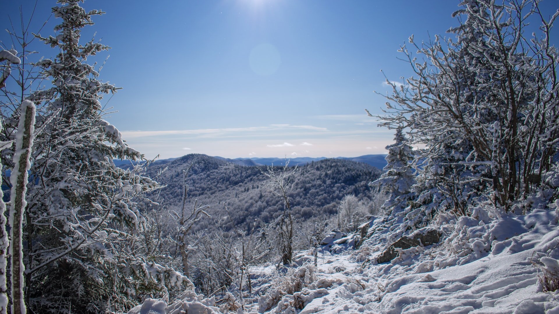
The Green Mountain State - Vermont is home to beautiful mountain ranges and views from Killington Peak, Camel’s Hump and Mount Mansfield.
Hike 100 miles of the Appalachian Trail - the Long Trail joins the AT in the southern terminus, up to the Maine junction (near Killington), before you hit the more rugged, mountainous section of the trail in the north.
Campsites and shelters - one of the few long distance trails to offer a choice of around 70 overnight sites, conveniently dotted along the trail around every 6 to 10 miles - sleep at a tent site, shelter or hut.
Easy to navigate - marked by white blazes from start to finish, the trail is relatively easy to navigate and well marked.
Late hiking season, up to mid-October - overseas travellers can avoid flying over the summer peak and save money on international flights.

Trail obstacles.
Vermont has it all, from black flies to bears!
Black flies and mosquitoes - just what you need right?! The Long Trail is popular with black flies and mosquitoes around mid June to late July.
Difficult and varied terrain - a difficult hiking trail, expect to encounter mud, snow, roots and rocks on the path - as well as lots of rain.
Vermont is often referred to as ‘Vermud’ by AT hikers, due to the mud season that typically occurs April to May. Yep, there’s a mud season.
Bear encounters - Green Mountain Club has reported increased bear activity on the trail in the past few years, requiring the use of a bear box, bear canister or preparations to hang your food.
The Long Trail map.
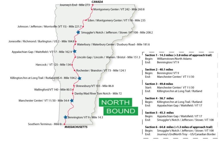
Trail map source: Long Trail Vermont
Border to border hike through Vermont, the Long Trail offers rugged terrain and is split into six sections with most people opting to hike northbound, from Massachusetts to Canada.
Elevation Profile.
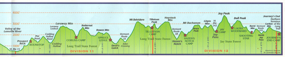
Elevation profile source: Groundbird Gear
How to get to North and South Terminus.
North Terminus:
Vermont/Canada border - Journey’s End Rd
From North Troy, VT
10 mile drive to the North Terminus - no public transport available.
South Terminus:
Massachusetts/Vermont state line
From Williamstown, MA:
3.5 miles drive from Williamstown to the state border line (catch a taxi or Uber) - followed by a short walk to the trailhead (less than 1 mile).
Official Trail Organisation.
Check out the official trail organisation’s website for the latest trail information, maps, events and more.

The Green Mountain Club
The Long Trail is managed by the Green Mountain Club, the founders of the Long Trail back in 1910. In addition to protecting and maintaining the Long Trail, the Green Mountain Club is responsible for the Vermont section of the Appalachian Trail.
Follow.
Be a part of the community and follow the Green Mountain Club online.
Frequently asked questions.

When is the best time to hike the Long Trail?
The Long Trail can be hiked from June to mid-October, however you may want to take into consideration the following when deciding when to start:
Black flies - late June to July
Weather conditions - heat, snow and mud
Crowds - the trail can be busy early summer
Aim for mid-September to avoid black flies and mosquitoes (although snow may be present at the higher elevations).
Hike northbound or southbound?
The most popular direction is hiking from south to north, as the first 100 miles are the easiest - allowing you to get your trail legs before you reach the more rugged and difficult northern section.
NOBO (Massachusetts to Canada border) is the most popular direction to hike
How long will it take?
Most hikers take around 3 to 4 weeks, however you may be quicker or slower, dependent on many factors such as:
Fitness level and total number of miles you want to cover on a daily basis
Total number of nero days (low number of miles hiked) and zero days (0 miles hiked) you take
Side trips you may want to take
Do I need a permit?
No permit is required to hike the Long Trail.
One less thing to worry about!
Is the trail well marked?
The full length of the trail is well marked by white blazes, found on trees or rocks - as well as standard signage at junctions.
Good preparation is key - e.g. carry paper maps, trail guide book and download the route app ahead of time.
How easy is it to re-supply?
The trail is close to many small towns, making it easy to re-supply - only requiring a few days of food to be carried at a time.
Carry up to 4-5 days food maximum

Connect with fellow thru-hikers online.
Join the ‘Long Trail Class of’ Facebook group and connect with fellow hikers who are planning to hike the same year as you!
Is public transport available?
Getting to and from the South Terminus is fairly easy as Williamstown is well serviced by public transport.
The North Terminus - not so much! You may have to pay for a shuttle or taxi to reach North Troy.
How is the water availability?
Water availability is good along the trail, due to the large number of rivers and streams that you will encounter.
You will need to be equipped and prepared to filter and/or purify all water collected.
Is the trail busy or quiet?
The first 100 miles will be busy, as you hike alongside Appalachian Trail thru-hikers, becoming more quiet for the last 170 miles.
Closest airports to North & South Terminus.
Guide to the closest airports you can fly in/out of when planning your overseas trip.
North Terminus

Vermont/Canada border
Nearest Airport - Burlington International Airport (BTV)
Direct flights available to BTV via multiple airports including JFK and EWR
From Burlington, 75 miles to North Troy (1 hr 30 mins drive) - no public transport available.
South Terminus

Massachusetts/Vermont state line
Nearest airport - Albany International Airport (ALB)
Direct flights available to ALB via multiple airports including EWR
From Albany, 50 miles to Williamstown (1 hr drive) - no public transport available.
Alternatively, fly into New York International Airport (JFK or EWR) and use public transport:
Williamstown is well serviced by public transport
From New York Port Authority, take the Peter Pan Bus Line direct to Williamstown (4 hr 35 mins)
International travellers - It might be cheaper to book a return flight to JFK/EWR - booking separate one way flights to/from BTV and ALB.