

Colorado Trail.
Choose your own route - Collegiate East or Collegiate West.

Colorado

486 - 491 miles

4 - 6 weeks

July - September
A continuous trail all the way from Denver to Durango with easy access to the north and south trailheads. The Colorado Trail is an epic thru-hike that will challenge you, taking you through remote backcountry - sharing miles with the Continental Divide Trail.
Learn about the Colorado Trail:
Why hike the Colorado Trail?
Trail map and elevation profile
Location of north and south trailheads
Colorado Trail Foundation
Frequently asked questions
Closest international airports

Why hike the Colorado Trail?
Get up close and personal with the natural beauty of Colorado, enjoying beautiful vistas among diverse terrains and fourteeners.
Fourteeners - Colorado is home to over 50 ‘fourteeners’ (mountains with an elevation @ 14,000+ feet), boasting more than half the fourteeners in the USA!
Continental Divide Trail - hike a small part of the CDT, aka the ‘rugged’ one of the Triple Crown of Hiking
234 miles of the trail is shared with the CDT - plus an additional 80 miles if you take the Collegiate West route.
Choose from two routes, East or West:
Collegiate East, 486 miles - original route of the Colorado Trail
Collegiate West, 491 miles - alternate route added around 2012
If you hike the Colorado Trail Collegiate loop (e.g. you hike the Collegiate East and Collegiate West routes), the total trail mileage is 567 miles

Trail obstacles
Suited to experienced hikers, due to the remote and ruggedness of the trail.
Remote hiking - trail is suited to experienced hikers who are comfortable hiking through several remote stretches.
High elevation trail - this isn’t an easy hike, averaging 10,300 feet in elevation - peaking at 13,271 feet in segment 22.
Extreme weather conditions - due to hiking at high elevations, expect all kinds of weather conditions - including thunderstorms, lightning, hail storms and snow storms.
Colorado Trail Map.

Trail map source: Colorado Trail Foundation
Divided into 33 segments, hike through National Forests, Wilderness areas and 8 of Colorado’s spectacular mountain ranges.
Elevation Profile.
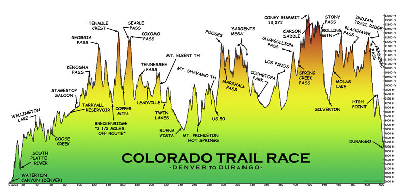
Looking at the elevation profile, you can see why most hikers head southbound from Denver to Durango, opting for a steady, gradual climb in the first few days - getting your trail legs before the higher elevations kick-in on the way into Durango.
Elevation profile source: Schillingsworth Shop
How to get to North Terminus and South Terminus.
Travelling to and from the trailheads is easy, located close to Denver and Durango.
North Terminus:
Waterton Canyon Trailhead, Denver
From Denver town centre:
25 miles from Denver town centre
No public transport is available to the trailhead, however you can catch the 'Regional Transportation District' (RTD) to within a few miles of the trailhead and then catch a taxi.
South Terminus:
Junction Creek Trailhead, Durango
From downtown Durango:
Trailhead is less than 2 miles from Junction Creek Campground
Easy to get to, less than 5 miles from downtown Durango
Simply hop in a taxi or Uber it!
Official Trail Organisation.
Check out the official trail organisation’s website for the latest trail information, maps, events and more.

The Colorado Trail Foundation
The Colorado Trail is managed by the Colorado Trail Foundation, a non-profit corporation funded by multiple stakeholders - from private individuals and companies, to foundations and the U.S. Forest Service.
Follow.
Be a part of the community and join the ‘Colorado Trail Class of’ Facebook group and connect with fellow hikers who are planning to hike the same year as you.
Make a donation.
Support the Colorado Trail Foundation in their mission to provide and maintain the trail as a linear, non-motorized, sustainable, recreation trail between Denver and Durango.
Frequently asked questions.

When is the best time to hike the Colorado Trail?
The Colorado Trail Foundation recommend hiking the trail from July to August, however the trail can be hiked from late June to September (subject to weather conditions).
July to September - 3 month hiking season
Hike northbound or southbound?
Most people hike SOBO (Denver to Durango), as the elevation gain is more gradual. 23 miles into a NOBO hike, you will be facing a 7,000 to 12,000 feet ascent.
Southbound (Denver to Durango) is the most popular direction to hike
Travelling from overseas, hiking southbound will give you more time to acclimatise to the high altitude
How long will it take?
Most hikers take around 4 - 6 weeks, however you may be quicker or slower, dependent on many factors such as:
Fitness level and total number of miles you want to cover on a daily basis
Total number of nero days (low number of miles hiked) and zero days (0 miles hiked) you take
Side trips you may want to take
Do I need a permit?
You don’t need a permit to hike the Colorado Trail, however when you pass through a wilderness area you are required by the U.S. Forest Service to self-service at the permit station and fill out a free permit.
No hiking permit required
Wilderness permits required - apply on the day you need it (self-service)
Is the trail well marked?
The Colorado Trail is considered to be well marked, making it reasonably easy to follow - although some sections may be easier to follow than others.
Like all hikes, good preparation is key - e.g. carry paper maps, trail guide book and download the route app ahead of time.
How easy is it to re-supply?
Re-supply should be fairly easy as there are lots of towns close to the trail - varying from less than a mile to around 40 miles.
Popular re-supply towns:
Breckenridge - 4 miles
Leadville - 8 miles
Buena Vista - 9.5 miles
Salida/Poncha Springs - 15 miles
Connect with fellow thru-hikers online.
Join the ‘Colorado Trail Class of’ Facebook group and connect with fellow hikers who are planning to hike the same year as you!
Is public transport available?
Although there is limited public transport available to and from the trailheads, you can easily travel by a taxi or Uber as the distances are fairly short.
How is the water availability?
Water availability is generally good as there are multiple water sources such as springs, streams, ponds and lakes - however you will need to be equipped and prepared to filter and/or purify all water collected.
Please note that for a small section of the hike water availability may be a harder to obtain and you may encounter minimal/no water for 20 to 40 miles (around sections 17 - 19).
Is the trail busy or quiet?
The Colorado Trail Foundation logged almost 350 people as a 'Colorado Trail Completer' in 2019 (hiking, cycling and horseback riding), with similar numbers in 2018 (340 in total) - generally, you may only encounter a few hikers a day.
As with all thru-hikes, you are more likely to meet day hikers and cyclists the closer to get to larger towns and popular trailheads.
Closest airports to North & South Terminus.
>> Guide to the closest airports you can fly in/out of when planning your trip <<
North Terminus:

Denver
Nearest Airport - Denver Airport (DEN)
Fly direct or via multiple US cities
South Terminus:

Durango
Nearest Airports - Santa Fe Airport (SAF) or Albuquerque (ABQ)
Tip: It might be cheaper to book a return flight to Denver, in addition to a one way to Santa Fe Airport.
