

Cycle across the USA.
Ride one of the most famous cycling routes in America.

Coast to Coast

4,215 miles

90 days

May - September
Pedal the TransAmerica Bicycle Trail through 10 states, from the Pacific Ocean on the west coast to the Atlantic Ocean on the east coast - get off the beaten track and experience rural USA on two wheels.
Learn about the TransAmerica Trail:
Why cycle the TransAmerica Trail?
Route map
Location of start and finish
Frequently asked questions
Closest international airports

Why cycle the TransAmerica Trail?
Revel in the simple joy of cross-country riding - no need to plan ahead, just go with the flow and travel at your own pace.
Slow travel - discover new places and meet new people, taking everyday as it comes - riding as fast or slow as you want, enjoying side trips as and when something looks interesting.
Close to civilisation - unlike hiking backcountry, travelling by bike allows you the security of knowing that you are never far away from civilisation - e.g. you don’t have to carry loads of food or water.
Solo cyclists - you are likely to see other cyclists as the route is well travelled and is popular with fellow cyclists - in addition, local communities are friendly and are accustomed to seeing cyclists.
Route highlights - Cycle through two iconic National Parks, Yellowstone National Park and Grand Tetons National Park, ride the Oregon Coastline, ride alongside the Appalachian Mountains along Blue Ridge Parkway and so much more.
Complete route in under 90 days - perfect for overseas travellers with an ESTA visa, only allowing 90 days in the USA.
Fun fact ‘wheel dip’ - cycling coast to coast, it is customary to dip your back wheel in the Pacific Ocean when you start and your front wheel in the Atlantic Ocean when you finish!

Headwinds.
Deal with all kinds of weather, impatient drivers, ‘friendly’ dogs barking at you and travelling overseas with a bike in tow.
Bike logistics, overseas travellers - do you fly with your touring bike or hire one when you get stateside? There are pros and cons to each - check out FAQ’s.
Road safety - you will need to keep your wits about you at all times, cycling 1,000’s of miles on paved roads and country highways - as well as watching out for local dogs that aren’t that keen on you cycling through their territory!
High visibility gear is a must - make sure your clothing and bike panniers are visible to drivers from a distance.
Weather conditions - ensure you are prepared and have the right gear for all types of weather conditions - from wind and rain to fires and extreme heat.
Routes avoid big cities - this can be good and bad! To avoid traffic, the TransAmerica route takes you through small cities, which is great if want to see rural USA - however it can be not so great if you are a first time traveller to the USA and want to see iconic places.
TransAmerica Route Map.
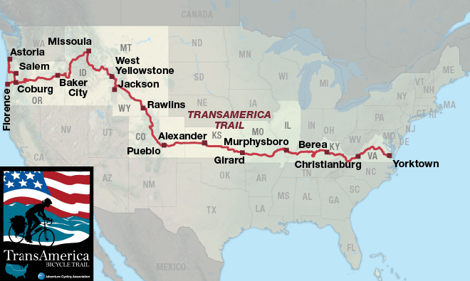
The TransAmerica Bicycle Trail is split into 12 sections - section 1 starts in Astoria, Oregon and section 12 ends in Yorktown, Virginia.
Oregon - home to Eugene, the largest town along the route
Idaho - cycle through Three Sisters, home to snow-capped volcanic peaks
Montana - swing by Adventure Cycling Association’s HQ in Missoula
Wyoming - take some time to enjoy Yellowstone National Park and Grand Tetons National Park
Colorado - Pueblo, CO marks the official half way point
Kansas - flattest state on route, ride in a straight line for 135 miles when you reach KS border!
Missouri - ride through quaint towns and enjoy short, steep climbs in the Ozarks area
Illinois - cross the Mississippi River into Carbondale, one of the larger towns on the route
Kentucky - visit Mammoth Cave National Park, the longest cave system in the world
Virginia - highest elevation gain of all states, enjoy views of Appalachian and Blue Ridge Mountains along the Blue Ridge Parkway
Location of start and end points.
West Coast: Astoria, Oregon
>> Columbia River Maritime Museum <<
Located in downtown Astoria, you can find the museum on the waterfront
1792 Marine Drive, Astoria
East Coast: Yorktown, Virginia
>> Yorktown Victory Monument <<
Overlooking the York River, the monument is located by the waterfront
803 Main St, Yorktown
Frequently asked questions.

When is the best time to cycle the TransAmerica Trail?
The Adventure Cycling Association advise that you can ride this route from May to September.
Dependent on which direction you take, you may want to start earlier/later - e.g. it can get very hot in certain states like Kansas and you may hit snow in high elevation areas like the the Rocky Mountains.
May - Sep > 5 month cycling season
Eastbound or Westbound?
Originally mapped for eastbound riding, the TransAmerica Route can be ridden eastbound or westbound - with riders experiencing comparable tailwinds and headwinds regardless of direction.
The highest total elevation gain is in Virginia, with eastbound riders benefiting from gaining their cycling legs before hitting tough climbs.
Eastbound - Oregon to Virginia
TransAm Bike Race is ridden eastbound
Westbound - Virginia to Oregon
How long will it take?
Most cyclists take up to 3 months, leaving plenty of time for sightseeing and side trips. You may be quicker or slower, dependent on many factors:
Fitness level and total number of miles you want to cover on a daily basis
60 to 65 miles is typical daily mileage
Total number of days off or low mileage days
Side trips you may want to take
Closest airports.
>> Guide to the closest airports you can fly in/out of when planning your trip <<
West Coast: Fly into Portland (PDX)

Nearest airport - Portland International Airport (PDX)
Fly direct to PDX or fly via multiple US Airports
From Portland - 100 miles to Astoria
East Coast: Fly into Norfolk (ORF)

Nearest airport - Norfolk International Airport (ORF)
Fly to ORF via multiple US Airports, including New York
From Norfolk, 40 miles to Yorktown
