Adventure Cycling Association - you rock!
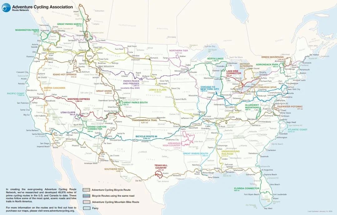
Choose your bike touring adventure from 29 mapped routes - covering 50,000 miles across North America.
Why ACA route maps?
40+ years experience researching and planning bicycle routes - all the hard work has been done for you!
Ride with confidence - choose your route, get the route map and you are good to go.
Routes are made for bike touring as they are designed by cyclists, for cyclists
Low-traffic roads, bicycle-friendly accommodation, inns, campgrounds, shops, key services and more are highlighted.
Maps are detailed and well travelled, catering for all interests - from National Parks and historical sights to natural wonders.
Paper route maps.
Beyond the endless joy of having maps spread across your kitchen table as you plan your trip, paper maps are helpful in many ways:
Elevation profile - plan your daily distance or day ahead by looking at the elevation profile.
Information at hand - designed to fit at the top of a handlebar bag, easily access useful information about the surrounding area as you cycle.
Bicycle Route Navigator App.
29 mapped routes available - purchase the entire route or a section.
Downloading the app is a great resource when you hit the road.
Easily calculate distance in miles from A to B, search for lodging, camping, food, bike shops, towns and other points of interest on the go.
The app can be used offline, so you don’t need to use your data if you are travelling from overseas (just make you sure you download the offline map before you arrive in the USA).
ACA’s route network.
Cross country, coastal or inland - the choice is yours.
Get off the beaten track as you navigate your way around the USA on two wheels.
Whilst you won’t be travelling the quickest route from A to B, you will be cycling the safest and more enjoyable way!
Cross country routes.
Bicycle Route 66 - Chicago, Illinois to Santa Monica, California > 2,499.6 miles
Southern Tier - San Diego, California to St. Augustine, Florida > 3022.5 miles
TransAmerica Trail - Astoria, Oregon to Yorktown, Virginia > 4,215.2 miles
Northern Tier - Anacortes, Washington to Bar Harbor, Maine > 4293.1 miles
Coastal routes.
Pacific Coast - Vancouver, British Columbia to Imperial Beach, California > 1848.6 miles
Atlantic Coast - Bar Harbor, Maine to Key West, Florida > 2611.8 miles
In land routes.
Great Parks South - Steamboat Springs, Colorado to Durango, Colorado > 695.0 miles
Great Parks North - Jasper, Alberta to Missoula, Montana > 741.0 miles
Sierra Cascades - Sumas, Washington to Tecate, California > 2400 miles
New route launched.
Parks, Peaks, and Prairies Bicycle Route - West Yellowstone, Montana to Minneapolis, Minnesota > 1,287 miles
ACA welcomes visitors in Missoula, Montana.
If you are cycling through Missoula, swing by ACA’s headquarters and say hi (I did)!


